

History of GPS Tracking Technology: From Cold War Innovation to Modern Navigation

The history of GPS tracking technology spans nearly seven decades from Cold War military secrecy to the invisible infrastructure now running in the pocket of every person on Earth. Understanding this journey explains how a system designed to guide nuclear missiles became the foundation of modern logistics, agriculture, finance, and navigation.
You open Google Maps without thinking. Fleet managers monitor vehicles across continents in real time. Taxi services dispatch drivers with pinpoint accuracy. Yet this technology that now defines modern life began as a classified military program, born from the same space race that put humans on the moon.
In this comprehensive guide, you'll learn how scientists first discovered the principles behind satellite navigation, how the United States government transformed those principles into a fully operational system, and where GPS technology is headed next.
The Cold War Catalyst: Sputnik and the Doppler Discovery
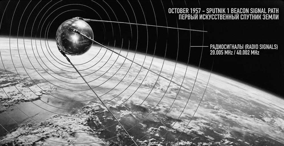
The story of GPS begins not with American innovation, but with Soviet triumph. On October 4, 1957, the Soviet Union launched Sputnik, the first satellite to orbit Earth. While the launch shocked American policymakers and ignited the space race, it also inadvertently provided the foundational science for satellite navigation.
American scientists at Johns Hopkins Applied Physics Laboratory noticed something interesting about Sputnik’s radio signal. As the satellite passed overhead, the frequency of its transmissions shifted predictably. This phenomenon, known as the doppler effect, allowed researchers to calculate Sputnik’s orbital position by measuring changes in signal frequency.
The implications were profound. If scientists could track a satellite’s position from the ground, the reverse should also be possible. A receiver on Earth could determine its own location by measuring signals from satellites with known positions. This insight sparked satellite navigation experiments that would eventually lead to the GPS system we rely on today.
From Tracking Satellites to Tracking Ships
The United States Navy immediately recognized the military potential. Submarines carrying nuclear missiles needed to know their precise location before launch traditional navigation was nowhere near accurate enough. A small positional error could cause a missile to miss its target by miles.
In 1958, Navy scientists began developing what would become the TRANSIT system the direct predecessor to modern GPS tracker. The first TRANSIT satellite successfully launched in 1960, proving the concept viable.
Early Navigation Systems: TRANSIT and OMEGA

Before GPS satellites orbiting the Earth could provide continuous global coverage, earlier systems attempted to solve the navigation problem with varying degrees of success.
The TRANSIT System
The TRANSIT program, officially the Navy Navigation Satellite System, became the world's first operational satellite navigation system. By the mid-1960s, a constellation of five satellites provided position fixes to naval vessels.
However, TRANSIT had significant limitations:
|
Limitation |
Impact |
|---|---|
|
Update frequency |
Fixes available only once per hour |
|
Positioning |
Two-dimensional only (no altitude) |
|
Coverage gaps |
Limited satellite visibility |
|
Accuracy |
Adequate for ships, insufficient for aircraft |
The OMEGA System
The OMEGA system, operational in the 1970s, used very low frequency radio transmissions from stations around the world. Users measured phase differences between station pairs to calculate position. OMEGA offered global coverage, but accuracy ranged from 2 to 4 nautical miles, acceptable for transoceanic voyages but inadequate for precision work.
Together, TRANSIT and OMEGA highlighted an urgent need: a system providing continuous, real-time, three-dimensional global positioning, accurate to meters, not miles.
Birth of the GPS Program: 1960s Foundations
The shift from earlier ideas to a single global positioning system (GPS) required combining several technologies and coordinating different government efforts.
The Aerospace Corporation’s Vision
In 1963, The Aerospace Corporation conducted a study that would shape the future of satellite navigation. Led by Phillip Diamond and inspired by Dr. Ivan Getting’s vision of “lighthouses in the sky,” the study recommended what became known as the 621-B concept.
The proposal outlined a revolutionary approach:
- Deploy satellites in medium Earth orbit (approximately 20,200 km altitude)
- Broadcast continuous signals enabling real-time location
- Support fast-moving vehicles on land, sea, and air
- Provide global, all-weather coverage
This concept directly framed the architecture that would define the GPS constellation for decades to come.
The Timation Program: Solving the Clock Problem
While the Air Force worked on improving positioning methods, the Navy’s Timation program focused on one of the most important challenges: accurate timing. GPS positioning depends on measuring how long signals take to travel from satellites to receivers. Since radio waves travel at the speed of light, even tiny timing errors translate to significant position errors. A clock error of just one microsecond produces a position error of approximately 300 meters.
The Timation program proved that atomic clocks could function reliably in the harsh environment of space:
- 1967-1968: Timation satellites launched with crystal oscillator clocks
- 1974: Third Timation satellite becomes first to carry a space-qualified atomic clock, achieving nanosecond-level timing accuracy

The NAVSTAR GPS Program Officially Launches
In December 1973, the U.S. Department of Defense officially established the NAVSTAR GPS program, consolidating Air Force and Navy efforts under a unified GPS project.
The program’s architecture defined what would become the standard for satellite navigation worldwide:
The Three Segments
|
Segment |
Components |
Function |
|---|---|---|
|
Space |
24+ satellites in 6 orbital planes |
Transmit navigation signals |
|
Control |
Ground control system with monitoring stations |
Track satellites, update orbit data |
|
User |
GPS devices and receivers |
Calculate position from signals |
The Trilateration Principle
The GPS system calculates position using a method called trilateration. Here’s how it works:
- A GPS receiver picks up signals from multiple satellites
- Each signal contains precise timing data and satellite position information
- The receiver calculates distance to each satellite using the formula: distance = speed of light × time of flight
- With distances to at least four satellites, the receiver solves for its own position (x, y, z coordinates) and clock bias
Four satellites are needed because the receiver has its own clock, which may not be perfectly matched with the satellites’ atomic clocks. The fourth satellite helps correct this clock error and improve accuracy.
Block I: The Experimental Phase
Corrected fact: The first Block I satellite launched from Vandenberg Air Force Base on February 22, 1978, carried by an Atlas F rocket. Delta II rockets were used for Block II satellites starting in 1989.
Between 1978 and 1985, the GPS program launched 11 Block I satellites. During this period, engineers conducted over 700 accuracy tests, confirming that the system could achieve meter-level precision.
Rockwell International manufactured these early satellites, establishing the industrial base that would support GPS production for decades.
Technical Foundations: How GPS Actually Works
Understanding the history of GPS requires grasping the technical innovations that made it possible.
Atomic Clock Technology
Every GPS satellite carries multiple atomic clocks using cesium and rubidium technology. These clocks maintain stability of approximately 10^-14 over 24 hours, meaning they lose or gain less than one second every 3 million years.
This exact timing allows all clocks to stay in sync, which is necessary for accurate positioning. Without it, the system would not work properly.
Signal Structure
GPS satellites transmit pseudorandom noise (PRN) codes modulated onto carrier waves. The corresponding GPS receiver on the ground correlates these codes to compute pseudoranges, estimated distances that include clock errors.
The original GPS signals included:
- L1 C/A (Coarse/Acquisition) code at 1575.42 MHz for civilian use
- P(Y) code at both L1 and L2 frequencies for military purposes
The P(Y) code provided enhanced accuracy but was encrypted, limiting access to armed forces personnel with proper decryption keys.
Positioning Calculations
Modern GPS data processing uses least-squares algorithms to solve for position. The receiver:
-
Acquires signals from visible satellites
-
Measures pseudoranges to each satellite
-
Applies corrections for atmospheric delays and satellite changes in position
-
Solves a system of equations for user position and clock bias
This entire process occurs in milliseconds, providing real-time location information to users worldwide.
How Did GPS Become Available to Civilians?
The transition from military-only GPS to civilian availability came through tragedy.
The Korean Air Lines Disaster
On September 1, 1983, Korean Air Lines Flight 007, a Boeing 747 carrying 269 people was shot down by Soviet interceptors after straying into prohibited airspace due to navigation errors. All 269 people aboard were killed.
The international reaction was immediate. The accident showed the weaknesses of existing civilian navigation systems and highlighted how useful accurate satellite navigation could be for commercial aviation. Two weeks later President Ronald Reagan announced that the United States would make GPS signals freely available to civil and commercial users worldwide once the system achieved operational capability. This policy directive declaring GPS a dual-use system changed the technology’s trajectory forever.
Building Toward Operational Capability
Following Reagan’s announcement, the GPS program accelerated. However, the 1986 Challenger disaster disrupted plans to launch GPS satellites via the Space Shuttle, forcing a return to expendable Delta II rockets. The first Block II operational satellite launched on February 14, 1989. These production satellites offered improvements over Block I prototypes:
- Longer operational lifespan
- Enhanced signal reliability
- Improved radiation hardening
By 1993, the system had achieved initial operational capability with a constellation of 24 satellites providing continuous global coverage.
The Selective Availability Era
While civil and commercial users could access GPS signals, they faced a significant limitation: Selective Availability.
What Was Selective Availability?
Selective availability was a Department of Defense policy that deliberately degraded the accuracy of civilian GPS signals. The us government intentionally introduced timing errors into the C/A code, limiting civilian horizontal accuracy to approximately 100 meters. Meanwhile, military receivers with proper encryption keys could access the P(Y) code, achieving 10-20 meter accuracy.
The reasoning behind selective availability centered on national security concerns. Defense planners worried that adversaries could use precise GPS positioning against U.S. interests guiding missiles to American targets or navigating hostile forces with military-grade accuracy.
The Standard Positioning Service
Under selective availability, commercial users worldwide received what was termed the standard positioning service. This degraded signal remained useful for many applications:
- Maritime navigation
- Aviation (with appropriate caution)
- Vehicle tracking (at reduced precision)
- Surveying (with differential correction techniques)
However, the artificial accuracy limitation frustrated civil users and constrained commercial innovation.
Workarounds and Differential GPS
Engineers developed techniques to overcome selective availability. Differential GPS (DGPS) used ground stations at known locations to calculate correction factors in real time. By broadcasting these corrections, DGPS could improve civilian accuracy to 1-5 meters even with SA active.
This technology enabled applications like precision agriculture and enhanced surveying, demonstrating the commercial potential that would explode once SA was removed.
Full Operational Capability: July 1995
The gps constellation achieved full operational capability on July 17, 1995. For the first time, 24 Block II/IIA satellites provided continuous, worldwide coverage.
This milestone transformed navigation across multiple sectors:
Aviation
Airlines began implementing GPS-based approaches, improving airport accessibility during poor weather conditions. The precise timing capabilities enabled better air traffic management.
Maritime
Commercial shipping adopted GPS for ocean navigation, replacing older systems like OMEGA. Port operations improved with precise vessel tracking.
Ground Transportation
Fleet managers began exploring GPS for logistics optimization. While selective availability limited accuracy, the system still offered advantages over previous navigation systems.
Military Applications
The Gulf War in 1991 provided GPS its first major combat test. GPS-guided munitions achieved 13-meter Circular Error Probable (CEP), compared to 100+ meters for conventional weapons. This dramatic improvement validated decades of investment.
May 2000: The Day GPS Changed Forever
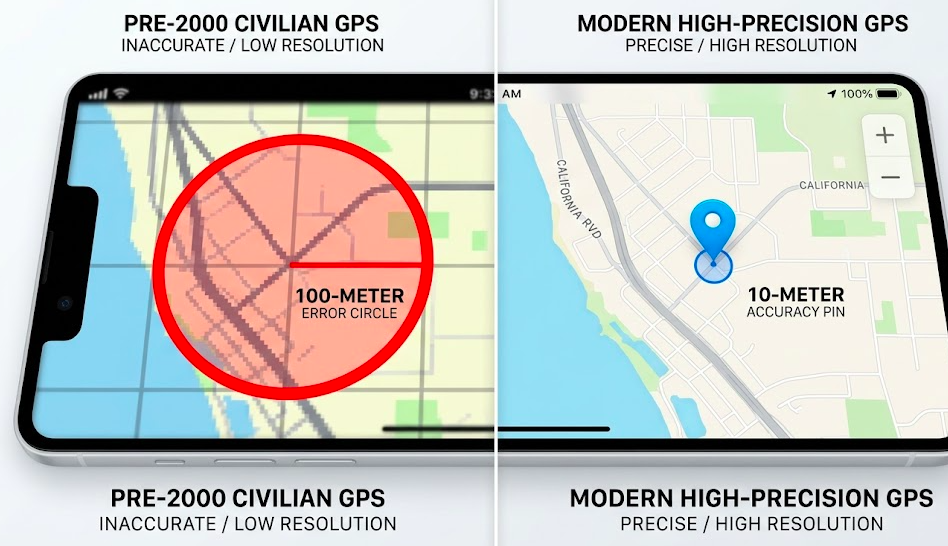
The most consequential moment in civilian GPS history occurred on the night of April 30 - May 1, 2000. President Bill Clinton issued an executive order terminating Selective Availability. Overnight, civilian GPS accuracy improved from ~100 meters to 10-20 meters.
Immediate Impact
The effects were dramatic and immediate:
|
Metric |
Before SA Termination |
After SA Termination |
|---|---|---|
|
Horizontal accuracy |
~100 meters |
10-20 meters |
|
Vertical accuracy |
~150 meters |
15-25 meters |
|
Commercial viability |
Limited |
Transformative |
Why End Selective Availability?
Several factors drove the decision:
- Economic pressure: American companies were losing market share to foreign competitors developing GPS augmentation systems
- Technical alternatives: The military had developed other methods to selectively deny access to GPS if needed
- Commercial potential: The government recognized GPS as a national asset with enormous economic value
- International relations: Maintaining SA created diplomatic friction with allies
The Clinton administration concluded that the benefits of open GPS access outweighed the security risks.
The Interagency GPS Executive Board
To manage GPS policy going forward, the government established the interagency gps executive board (later reorganized under President George W. Bush in 2004 as the National Space-Based PNT Executive Committee). This body coordinated GPS policy across agencies including the Department of Defense and homeland security.
The Consumer Revolution Begins
GPS tracking devices proliferated rapidly. The first consumer GPS device Magellan's NAV 1000, had launched in 1989 for $3,000, but adoption was minimal during the SA era. After May 2000, the market exploded with dedicated vehicle navigation units, handheld outdoor GPS devices, and GPS-enabled PDAs.
Integration with Mobile Phones
The most transformative development came when GPS integrated with cellular technology. Qualcomm’s assisted GPS technology, introduced commercially around 2004, combined satellite signals with cellular tower triangulation.
A-GPS addressed key limitations of standalone GPS:
- Faster acquisition times (reducing cold-start delays from 30+ seconds)
- Improved performance in urban canyons and parking garages where satellite signals struggle
- Sub-10-meter accuracy even in challenging environments
Today, virtually every smartphone includes a GPS receiver, enabling the location-based services that define modern commerce.
Modern GPS Evolution: Block IIR, IIF, and III
The GPS satellite constellation has evolved continuously since initial deployment.
Block IIR Satellites
Beginning in 1997, Block IIR satellites introduced modernized capabilities. The 2005 launch of the first IIR-M variant added the L2C signal at 1227.60 MHz, providing:
- Improved multipath resistance (reducing errors from signal reflections)
- Faster cold-start times for receivers
- A second civilian frequency for enhanced accuracy
Block IIF Satellites
Launches beginning in 2010 brought Block IIF satellites with the L5 “safety-of-life” signal at 1176.45 MHz. This frequency supports aviation applications requiring the highest reliability.
The L5 signal enables:
- Improved interference resistance
- Better performance in challenging signal environments
- Enhanced integrity monitoring for critical applications
GPS III: The Current Generation
The first gps III satellite launched in December 2018, representing the most significant capability upgrade in GPS history.
GPS III improvements include:
|
Feature |
Improvement |
|---|---|
|
Signal power |
3x stronger than previous generation |
|
Accuracy |
Enhanced positioning precision |
|
Anti-jam capability |
Improved resistance to interference |
|
Laser retroreflectors |
Enable ground-based orbit determination accurate to 10cm |
|
Lifespan |
15-year design life |
As of 2026, more than 10 GPS III satellite vehicles have launched, with the U.S. Space Force continuing deployments to modernize the constellation. The advanced GPS technology in GPS III ensures the system remains capable through the 2040s and beyond.
How Businesses Leverage GPS Technology Today
The commercial applications of GPS have expanded far beyond simple navigation.
Fleet Management
Fleet GPS tracking use to optimize transportation operations across industries, enabling real-time vehicle location monitoring, route optimization (reducing fuel consumption by 10–20%), driver behavior analysis, automated dispatch, and proof-of-delivery documentation. Companies that monitor fleets effectively gain measurable competitive advantages in efficiency and customer service.
Precision Agriculture
Farmers use GPS data to drive centimeter-level planting accuracy, automated tractor guidance, and variable-rate application of fertilizers and pesticides. Studies indicate precision agriculture techniques enabled by GPS can increase crop yields by approximately 15% while reducing input costs.
Financial Services
GPS timing synchronizes financial transactions worldwide. Approximately 90% of financial institutions rely on GPS timing for transaction timestamps, ensuring the integrity of global markets. A GPS outage would disrupt trading systems far beyond navigation.
Other Applications
- Asset tracking: Construction equipment, shipping containers, high-value cargo
- Personal safety: Emergency response, elderly monitoring, child safety devices
- Scientific research: Earthquake monitoring, climate measurement, plate tectonics
GPS vs GLONASS, Galileo, and BeiDou: How Do They Compare?
While GPS remains the dominant satellite navigation system, four global GNSS (Global Navigation Satellite System) constellations now operate, and modern receivers use them simultaneously.
Competing Systems
|
System |
Country |
Satellites |
Accuracy |
Signal Type |
|---|---|---|---|---|
|
GPS |
United States |
31 |
3-10m |
CDMA |
|
GLONASS |
Russia |
24 |
5-10m |
FDMA |
|
Galileo |
European Union |
30 |
1-3 m (standard) |
CDMA |
|
BeiDou |
China |
35+ |
2.5-10m |
Mixed |
Multi-constellation GNSS receivers provide improved accuracy through additional satellite visibility, better performance in challenging environments, and RTK (Real-Time Kinematic) precision of 1-5 centimeters for professional applications.
GPS Vulnerabilities and Challenges
Despite its capabilities, GPS faces significant challenges.
Jamming
GPS signals arriving at Earth's surface are relatively weak, roughly equivalent to a 20-watt light bulb seen from 20,000 km. Simple jamming devices can block GPS reception over areas of several kilometers, posing risks to aviation, shipping, and emergency services.
Spoofing
More sophisticated attackers can transmit fake GPS signals, causing receivers to calculate incorrect positions. Spoofing poses particular risks for:
- Autonomous vehicles
- Drone navigation
- Maritime shipping
- Financial timing systems
Natural Interference
Solar flares and ionospheric disturbances can induce position errors of 20 meters or more. While most applications tolerate this variability, safety-critical uses require augmentation systems.
Countermeasures
- M-code: Modernized military signal with enhanced anti-jam capabilities (operational since 2019)
- Multi-frequency receivers: Using L1, L2C, and L5 simultaneously reduces vulnerability
- Inertial navigation backup: Combining GPS with IMUs provides continuity during outages
- Authentication signals: GPS III's new civilian authentication capability helps detect spoofing
The Future of GPS Technology
GPS technology continues advancing rapidly.
5G and LEO Integration
Integration with 5G networks and low Earth orbit (LEO) satellite constellations promises sub-meter accuracy for consumer devices, improved indoor positioning, and reduced acquisition times. Starlink and other LEO providers are actively experimenting with PNT signals that could augment traditional GPS.
AI-Enhanced Navigation
Machine learning algorithms now improve GPS accuracy by:
- Predicting atmospheric delays based on historical patterns
- Filtering multipath errors in urban environments
- Optimizing receiver processing for faster fixes
Quantum Clocks
Looking further ahead, quantum clock technology may revolutionize positioning accuracy. By 2030, quantum-enhanced timing could enable millimeter-level positioning, opening applications not yet imagined.
Alternative PNT Technologies
Researchers are developing backup systems that function without satellites:
- Optical navigation using star trackers
- Advanced inertial navigation systems
- Ground-based timing networks
These alternatives ensure resilience against GPS denial scenarios.

GPS Today: A National Resource
What began as military technology now generates over $1 trillion in annual economic value globally. GPS underpins:
- Transportation efficiency saving billions in fuel and time
- Disaster response enabling rapid emergency coordination
- Scientific research from earthquake monitoring to climate study
- Personal convenience through smartphone navigation
The GPS today serves as critical infrastructure, recognized by the united states government as a national asset requiring protection and continued investment.
Key Takeaways
- The history of GPS tracking technology began with Sputnik in 1957, when MIT scientists discovered satellite signals could enable position determination via the Doppler effect
- The U.S. Navy's TRANSIT system proved satellite navigation viable, leading to the consolidated NAVSTAR GPS program approved in December 1973
- Technical breakthroughs in atomic clocks, especially Timation's 1974 space-qualified atomic clock, made precise timing (and therefore accurate positioning) possible
- The 1983 Korean Air Lines disaster prompted President Reagan to commit to civilian GPS access
- GPS reached Initial Operational Capability (IOC) on December 8, 1993, and Full Operational Capability (FOC) on April 27, 1995 (announced July 17, 1995)
- President Clinton terminated Selective Availability on May 1, 2000, making civilian GPS 10× more accurate overnight
- GPS III satellites deliver 3× stronger civilian signals and up to 8× greater anti-jamming capability versus previous generationsConclusion
Conclusion
The journey from Sputnik's radio signal to your smartphone's real-time navigation represents one of humanity's most remarkable technological achievements. The history of GPS tracking technology is a story of military necessity, scientific ingenuity, policy decisions, and geopolitical pressure combining to create infrastructure that now touches virtually every aspect of modern life.
GPS continues evolving. The U.S. Space Force maintains and upgrades the constellation. New satellite generations launch regularly. The integration of GPS with AI, 5G, and quantum timing technologies promises accuracy improvements that would astonish the engineers who first tracked Sputnik's signal in 1957.
Whether you're a fleet manager optimizing logistics, a farmer guiding an autonomous tractor, or someone navigating to an unfamiliar destination, a GPS tracker works silently in the background, providing the location information that modern operations depend upon. And its evolution is far from complete.
Frequently Asked Questions
Who invented GPS?
GPS was developed by the U.S. Department of Defense as a joint military program. Key inventors include Roger L. Easton (Naval Research Laboratory), Ivan A. Getting (The Aerospace Corporation), and Bradford Parkinson (Air Force), who led the consolidated NAVSTAR program from 1973. The mathematician Gladys West's geodetic Earth model was also instrumental in the system's development.
When did GPS become available to the public?
Limited civilian GPS access began in the late 1980s following President Reagan's 1983 directive, but accuracy was deliberately capped at ~100 meters. On May 1, 2000, President Clinton terminated Selective Availability, making full-precision GPS freely available to civilians worldwide-improving accuracy roughly 10-fold overnight.
How accurate is GPS today?
Modern civilian GPS provides horizontal accuracy of approximately 3-10 meters under good conditions. GPS III satellites offer enhanced precision. Augmentation systems like DGPS and RTK (Real-Time Kinematic) can achieve centimeter-level accuracy for professional applications.
What was GPS originally used for?
GPS was originally developed for U.S. military use primarily to give nuclear submarines precise position fixes before launching ballistic missiles. It expanded to aircraft navigation and precision-guided munitions before becoming a civilian technology.
What is the difference between GPS and GNSS?
GPS (Global Positioning System) is the American system. GNSS (Global Navigation Satellite System) is the umbrella term covering GPS plus Russia's GLONASS, Europe's Galileo, and China's BeiDou. Modern smartphones and fleet tracking devices typically use multiple GNSS systems simultaneously for improved accuracy and reliability.
How many GPS satellites are there?
As of 2026, the GPS constellation has 31+ operational satellites, exceeding the original 24-satellite design requirement. The extra satellites improve accuracy, provide redundancy, and ensure continuous coverage globally. The U.S. Space Force maintains and operates the constellation.
Posted by Kellie Kendall on Feb 19th 2026